| Great Bend-Overly silt loams, 2 to 6 percent slopes | F482B | 1495 | 2587668 | 2q561 | nd005 | | 1:12000 |
Overly-Great Bend silty clay loams, 0 to 2 percent slopes | F487A | 17792 | 2585989 | 2q567 | nd009 | 1981 | 1:20000 |
Great Bend-Overly silt loams, 0 to 2 percent slopes | F482A | 558 | 2585908 | 2q560 | nd009 | 1981 | 1:20000 |
Great Bend-Overly silt loams, 0 to 2 percent slopes | G482A | 357 | 2576316 | 2q5nn | nd027 | | 1:12000 |
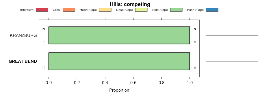
Great Bend silty clay loam, 6 to 9 percent slopes | I179C | 10 | 2642573 | 2qkvg | nd035 | 1980 | 1:20000 |
Great Bend-Overly silt loams, 0 to 2 percent slopes | F482A | 5583 | 2585605 | 2q560 | nd049 | 1987 | 1:20000 |
Great Bend-Overly silt loams, 0 to 2 percent slopes | F482A | 633 | 2587193 | 2q560 | nd069 | 1975 | 1:20000 |
Great Bend-Overly silt loams, 2 to 6 percent slopes | F482B | 625 | 2587143 | 2q561 | nd071 | 1984 | 1:12000 |
Great Bend-Overly silt loams, 0 to 2 percent slopes | F482A | 20 | 2587142 | 2q560 | nd071 | 1984 | 1:12000 |
Great Bend-Overly silt loams, 0 to 2 percent slopes | F482A | 1727 | 2585346 | 2q560 | nd075 | 1972 | 1:20000 |
Great Bend-Overly silt loams, 0 to 2 percent slopes | F482A | 4529 | 2588026 | 2q560 | nd079 | 1990 | 1:24000 |
Great Bend-Overly silt loams, 2 to 6 percent slopes | G482B | 47 | 2579440 | 2q5np | nd081 | 1959 | 1:12000 |
Great Bend-Overly silt loams, 2 to 6 percent slopes | G482B | 53 | 2581385 | 2q5np | nd093 | 1990 | 1:24000 |
Great Bend-Overly silt loams, 0 to 2 percent slopes | F482A | 10432 | 2586206 | 2q560 | nd095 | 1992 | 1:24000 |
Great Bend-Zell silt loams, 2 to 6 percent slopes | F483B | 1557 | 2587064 | 2q562 | nd095 | 1992 | 1:24000 |
Great Bend-Overly silt loams, 2 to 6 percent slopes | F482B | 73 | 2587030 | 2q561 | nd095 | 1992 | 1:24000 |
Overly-Great Bend silty clay loams, 2 to 6 percent slopes | I174B | 1542 | 2642480 | 2l6xc | nd097 | 1974 | 1:20000 |
Great Bend silty clay loam, 6 to 9 percent slopes | I179C | 1434 | 2642473 | 2qkvg | nd097 | 1974 | 1:20000 |
Great Bend silty clay loam, 0 to 2 percent slopes | I179A | 999 | 2642472 | 2qkvf | nd097 | 1974 | 1:20000 |
Great Bend silty clay loam, 9 to 15 percent slopes | I179D | 795 | 2642474 | 2qkvh | nd097 | 1974 | 1:20000 |
Great Bend silty clay loam, 6 to 9 percent slopes | I179C | 1113 | 2642883 | 2qkvg | nd099 | 1967 | 1:20000 |
Great Bend-Overly silt loams, 0 to 2 percent slopes | F482A | 209 | 2585130 | 2q560 | nd101 | 1967 | 1:20000 |
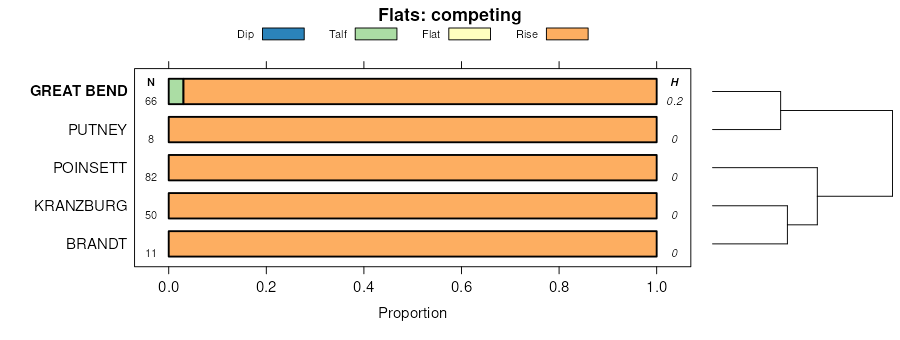
Great Bend-Beotia silt loams, 0 to 2 percent slopes | G720A | 68152 | 2797807 | 2sd52 | sd013 | 1987 | 1:20000 |
Great Bend-Putney silt loams, 0 to 2 percent slopes | G724A | 25120 | 2797812 | 2sd58 | sd013 | 1987 | 1:20000 |
Great Bend-Beotia silt loams, 2 to 6 percent slopes | G720B | 23037 | 2797808 | 2sd53 | sd013 | 1987 | 1:20000 |
Great Bend-Zell silt loams, 6 to 9 percent slopes | G722C | 9543 | 2797810 | 2sd56 | sd013 | 1987 | 1:20000 |
Great Bend-Zell silt loams, 2 to 6 percent slopes | G722B | 1331 | 2797809 | 2sd55 | sd013 | 1987 | 1:20000 |
Zell-Great Bend silt loams, 6 to 25 percent slopes | G722E | 1321 | 2797811 | 2sd57 | sd013 | 1987 | 1:20000 |
Great Bend-Zell-Huffton silt loams, 6 to 9 percent slopes | G725C | 1027 | 2797814 | 2sd5b | sd013 | 1987 | 1:20000 |
Great Bend-Putney silt loams, 2 to 6 percent slopes | G724B | 511 | 2797813 | 2sd59 | sd013 | 1987 | 1:20000 |
Great Bend-Zell silt loams, 2 to 6 percent slopes | Z322B | 234 | 2765259 | 2qkmh | sd029 | 2006 | 1:12000 |
Zell-Great Bend silt loams, 9 to 15 percent slopes | Z323D | 115 | 2765260 | 2qkmj | sd029 | 2006 | 1:12000 |
Great Bend-Zell silt loams, 6 to 9 percent slopes | J137C | 85 | 1685542 | 1tkyb | sd029 | 2006 | 1:12000 |
Great Bend-Beotia silt loams, 0 to 2 percent slopes | J136A | 74 | 1685538 | 1tky6 | sd029 | 2006 | 1:12000 |
Great Bend-Beotia silt loams, 0 to 2 percent slopes | G720A | 552 | 2798519 | 2sd52 | sd037 | 1992 | 1:20000 |
Great Bend-Beotia silt loams, till substratum, 0 to 2 percent slopes | G721A | 519 | 2798520 | 2sd54 | sd037 | 1992 | 1:20000 |
Great Bend-Putney silt loams, 0 to 2 percent slopes | G724A | 373 | 2798521 | 2sd58 | sd037 | 1992 | 1:20000 |
Great Bend-Zell-Huffton silt loams, 6 to 9 percent slopes | G725C | 356 | 2798522 | 2sd5b | sd037 | 1992 | 1:20000 |
Zell-Great Bend silt loams, 9 to 15 percent slopes | Z323D | 18 | 2712916 | 2qkmj | sd051 | 1977 | 1:20000 |
Great Bend-Zell silt loams, 2 to 6 percent slopes | Z322B | 8 | 2712915 | 2qkmh | sd051 | 1977 | 1:20000 |
Great Bend-Beotia silt loams, 2 to 6 percent slopes | G720B | 4884 | 2799364 | 2sd53 | sd091 | 1970 | 1:20000 |
Great Bend-Beotia silt loams, 0 to 2 percent slopes | G720A | 3432 | 2799363 | 2sd52 | sd091 | 1970 | 1:20000 |
Great Bend-Zell silt loams, 2 to 6 percent slopes | G722B | 1146 | 2799366 | 2sd55 | sd091 | 1970 | 1:20000 |
Great Bend-Zell-Huffton silt loams, 6 to 9 percent slopes | G725C | 249 | 2799370 | 2sd5b | sd091 | 1970 | 1:20000 |
Great Bend-Zell silt loams, 6 to 9 percent slopes | G722C | 222 | 2799367 | 2sd56 | sd091 | 1970 | 1:20000 |
Great Bend-Beotia silt loams, till substratum, 0 to 2 percent slopes | G721A | 202 | 2799365 | 2sd54 | sd091 | 1970 | 1:20000 |
Great Bend-Putney silt loams, 0 to 2 percent slopes | G724A | 85 | 2799368 | 2sd58 | sd091 | 1970 | 1:20000 |
Great Bend-Putney silt loams, 2 to 6 percent slopes | G724B | 13 | 2799369 | 2sd59 | sd091 | 1970 | 1:20000 |
Great Bend-Beotia silt loams, 0 to 2 percent slopes | G720A | 59663 | 2799625 | 2sd52 | sd115 | 1997 | 1:24000 |
Great Bend-Zell silt loams, 2 to 6 percent slopes | G722B | 21734 | 2799628 | 2sd55 | sd115 | 1997 | 1:24000 |
Great Bend-Putney silt loams, 0 to 2 percent slopes | G724A | 6390 | 2800031 | 2sd58 | sd115 | 1997 | 1:24000 |
Great Bend-Zell silt loams, 6 to 9 percent slopes | G722C | 5539 | 2799629 | 2sd56 | sd115 | 1997 | 1:24000 |
Great Bend-Beotia silt loams, 2 to 6 percent slopes | G720B | 3740 | 2799626 | 2sd53 | sd115 | 1997 | 1:24000 |
Great Bend-Beotia silt loams, till substratum, 0 to 2 percent slopes | G721A | 3086 | 2799627 | 2sd54 | sd115 | 1997 | 1:24000 |
Great Bend-Putney silt loams, 2 to 6 percent slopes | G724B | 2253 | 2800032 | 2sd59 | sd115 | 1997 | 1:24000 |
Zell-Great Bend silt loams, 6 to 25 percent slopes | G722E | 1287 | 2800030 | 2sd57 | sd115 | 1997 | 1:24000 |
Great Bend-Zell-Huffton silt loams, 6 to 9 percent slopes | G725C | 678 | 2800033 | 2sd5b | sd115 | 1997 | 1:24000 |
Great Bend-Beotia silt loams, till substratum, 2 to 6 percent slopes | G721B | 554 | 2800063 | 2sl3r | sd115 | 1997 | 1:24000 |
Great Bend-Putney silt loams, 0 to 2 percent slopes | GpA | 7 | 356630 | cz36 | sd115 | 1997 | 1:24000 |


